quarta-feira, 11 de dezembro de 2013

Biodiesel

Biodiesel is a fuel made from a vegetable oil by chemically reacting lipids with an alcohol. Biodiesel is used as a alternative fuel replacing fossil fuel for diesel engines, being used by itself or combined with petroleum diesel. The reaction is shown below:

Biodiesel can be used as vehicular fuel, heating oil, cleaning oil. Some typical yields are from chinese tallow, palm oil, coconut, rapeseed, soy (image below), peanut, sunflower.

Soy biodiesel. (Source)

The Twelve Soils of the World

There are 12 soils categories around the world. The soils taxonomy places these 12 categories called orders. They are:

Gelisols | Histosols | Spodosols | Andisols | Oxisols | Vertisols | Aridisols | Ultisols | Mollisols | Alfisols | Inceptsols | Entisols

At this link, we can obtain more information about the 12 orders and see the distribution of these orders in the USA.

The image below shows us the distribution of these 12 orders around the world.

Soil Orders around the world. (Source: http://www.cals.uidaho.edu/soilorders/i/worldorders.jpg)


segunda-feira, 11 de novembro de 2013

Community Urban Gardens

A community garden is any piece of land gardened by a group of people. It can be urban, suburban, or rural, where people can plant flowers, vegetables or ornamental plants.
Community gardens have lots of benefits, among them,we can state the improvement of the quality of life for people in the garden; preservation of green spaces; reduction of city heat from streets and parking lots. American community gardening in urban areas is cleaning up abandoned vacant lots and turning them into procutive gardens, helping to reduce crimes and stimulating social interaction.

Source: http://archives.rooftopgardens.ca/image/tid/130.html

Community gardens creates opportunity for recreation, exercise, therapy, and education, and it's a good opportunity to envolve children with the nature.

Source: http://www.hgdecoration.com/gallery/community-gardens/community-gardens1.jpg

For more information about how to start a community garden in your neighborhood, or for tips, articles and a bunch of other stuff, there's is the American  Community Gardening Association website, http://www.communitygarden.org/.
There you can learn more about community gardens and get information on how to be more involved in a community garden near you.

In Macon, there are the North Macon Park Community Garden and the Pleasant Hill Community Garden seen at the image below.

Community Garden in Macon, GA. Source: http://acga.localharvest.org/garden/M728

quarta-feira, 30 de outubro de 2013

Trees all over the world

Araucaria araucana

The Araucaria araucana is a tree in the genus Araucaria. Known as Monkey Puzzle, it grows to 40 metres tall with a 2 metres trunk diameter. Its native habitat is the Chilean and Argentinian slopes of the south-central Andes.
The leaves are thick, tough, triangular, with sharp edges and tip. What concerns the reproduction, it is usually dioecious, with the male and female cones on separate trees. The tree is wind pollinated.
In the genus Araucaria there are 19 extant species distributed in the south hemisphere, with species in New Guinea, Australia and Brazil, for example. For more information, click here.

Araucaria araucana. Source: http://www.elicriso.it/es/como_cultivar/araucaria/


Ficus sycomorus

The Ficus sycomorus is a fig species, called sycamore fig or just sycamore. It grows to 20 m tall and 6 m wide. The leaves are heart shaped. It is native to Africa and there the trees are usually found in rich soils along rivers and in mixed woodlands. The fruit is a large edible fig, with 2 to 3 cm in diameter. For more information, click here.

Ficus sycomorus. Source: http://www.flickriver.com/photos/oom_piet/3691645326/


Caesalpinia echinata (Pau brasil)

The Caesalpinia echinata is a famous brazilian tree known as Pau Brasil. It's a tree in the pea family. It has an orange-red heartwood, and it is used for making bows for stringed instruments. That's because of it Brazil received its name. When the Portuguese navigators arrived in 1500, the pau-brasil was extremely abundant in the whole brazilian coast. Because of its exploration since the 16th century, the specie is nearly extirpated. For more information, click here.

Caesalpinia echinata. Source: http://www.sabianatureza.com.br/wp-content/uploads/2013/09/pau_brasil_03.jpg

quinta-feira, 24 de outubro de 2013

Ocmulgee River

During the field trip to the Ocmulgee River, in Macon-GA, a collection of data allowed us to estimate the transection's elevation of the Ocmulgee River.
Using the software Google Earth, we were able to see the area from above and extract the elevation profile, both seeing below.


Near the point studied, there is a trail all long the riverside, the Ocmulgee Heritage Greenway. The path is a must see ride. You can check more informations here.

The Mistery of the Megaflood

The  Mystery of the Megaflood is a documentery aired by PBS that investigate the unusual landscapes of Channeled Scablands, in the state of Washington.
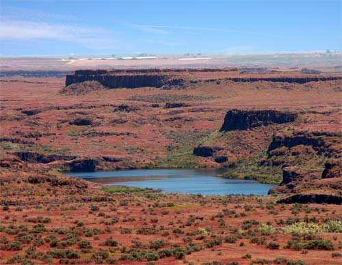
The geologists worked as detectives, behind clues that could explain the bizarre features at the valley. At first, it seemed to be related to rivers that may have come through the valley. But there were somethings that could not be explained by a river action, like de giant puddles.
The other hypothesis that would explain that would be ice. A slow-moving ice originated from the last Ice Age would explain the valley formation. However, the ice sheets that flowed down from Canada during the last Ice Age never reached the Scablands.
The last theory, the most outrageous, said it was a result from an enormous catastrophe that happened almost overnight: a single giant flood, resulted from the rupture of a ice dam in the Glacial Lake Missoula.
More than one megaflood may be happened. Ice dams collapsed and re-formed in a cycle that rocked the Scablands again and again.

File:Drum-Heller-Channels.jpg
Drumheller Channels. Source: http://upload.wikimedia.org/wikipedia/commons/5/55/Drum-Heller-Channels.jpg

sábado, 21 de setembro de 2013

Topographic Map - Serra do Mar - Sao Paulo/Brazil

This is the topographic map of a region in Brazil known as Serra do Mar. The image represents only a small piece of all the Serra do Mar, because it is an extensive mountain chain located at the southeast coast of Brazil. The image below shows one of the most famous roads of Sao Paulo, Rodovia Anchieta. It connects the biggest Metropolitan area of Brazil to the south coast of Sao Paulo.